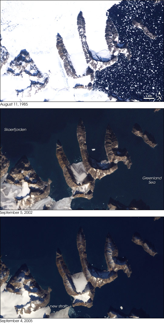
Melting Ice Reveals New Island off Greenland
Then again, remember it is still just a matter of perspective. The island revealed in this photo is obviously part of the same mountain range that was thought to be continuous, except in this case, instead of being connected under ice, it is connected under water. The ice is just one layer of the topographic onion. If you remove the water, then the further analysis of topography can continue.
The Earth's surface can roughly be divided into two categories: Ocean Floors and Continent Land Masses. While it would be tempting to distinguish them by the simple presence of water, that would not only be incorrect but also be attributing water to the reason for a difference. The rocks of these two types of land have different chemical compositions, physical attributes and geologic history. It is these concrete differences that results in one being mostly under water and one not, though in fact there are many cases where the ocean floor is exposed above water (Iceland being the most famous example) and where the continental land mass is under water.
Most maps today show the borders of continents to be where the current coast line is, rather than the boundary where continent meets ocean floor. The reason for this is that the oceans have flooded large parts of our continents creating shallow seas. The parts of the continent that are flooded are what we call continental shelves.
This map shows the continents with the continental shelves visible in light blue:

While Greenland is a continental land mass and is most certainly surrounded by water, it does not rise from ocean floor and is not its own continental land mass. As this map shows, it is in fact part of the North American continent.
This makes us beg the question: What is the true definition of an island? In Bali there is a famous Hindu temple that is only accessible by a land bridge at low tide. In Europe there are myriads of castles that are in a similar position. In Maine there are many summer homes that momentarily become islands with the flow of tides. Are these truly islands though? A home owner might like the cachet of saying s/he owns a private island, but it would be a rather dubious claim.
Then again, no one doubts that Greenland is an island. But, in the grand scheme of earth’s geologic time (4.6 billion years and counting), the ebb and flow of tidal waters are not that different from the rising and falling of global sea levels. Instead of rowing over them, there have been many times when it would have been possible to walk up and down the ridges and the valleys of the current continental shelf from Canada to Greenland. The presence of deep canyons eroded by rivers that once flowed to the edge of the continent provide clear proof that this land was once above the sea level.
By peeling away the ocean layer of the onion one can realize how the boundaries we apply to our visualization of the Earth are often just arbitrary and one of many possible options. The melting of glaciers might provide for new surprises in the future (including hermetically sealed liquid lakes kilometers under the Antarctic Ice) but that very melting is causing global ocean levels to rise thereby further shrouding complex topographies under a flat water line.
No comments:
Post a Comment