Saturday, November 12, 2011

Icebergs and Mountainbergs


We have discussed how the Greenland glacier is kilometers thick, providing a scaffolding to stroll high above the island's mountains and deep valleys rather than up and down them (I guess this is a form of both walking on water and walking on air!). We have also discussed how rising oceans allow you the luxury of paddling over the mountains and deep canyons of continental shelves, again sparing you from trudging along the landscape.

These submerged mountain-scapes are very real, but are just hidden from plain view and rarely factor into our representations of the Earth. If one takes the effort to visualize these landscapes however, it opens up a whole new world of exploration and aesthetic awe. Having already gone below the ocean level however, is it possible to go even further down? Can we explore the landscape below the surface level?  In order to answer this, we first need a little basic knowledge of the Earth’s composition.

One generally assumes that the Earth’s oceans collectively make up the largest fluid body on our planet. After all 75% of the Earth’s surface is covered by oceans! The key word to the previous oft-quoted statistic however is “surface”. If you scratch beyond the surface however, a much, much larger fluid body can be found.

Below the Earth’s surface is a hot semi-solid layer that can flow and behave like a fluid. This layer, called the mantle, is roughly 2,900 km thick, and it is clearly this body that is the largest fluid body of the Earth. There are places on the Earth where this hot fluid mantle is visible (Iceland and Hawaii being two prime examples), but unlike the ocean, this fluid body is pretty much fully obscured by the Earth’s oceanic and continental crusts that float on top of it, which on average are just 5km and 30km thick respectively..  

So if the visual world as we know it, rocks, oceans and all, is just floating on fluid mantle, then what is going on under the surface? Well, as it turns out, not that different from what is underneath the tip of the iceberg.


Mountains, just like icebergs have the majority of their mass under the surface. Ice generally has a submerged to exposed ratio of 9:1. Because mountains are floating on a material that is a lot more viscous and dense than sea water, the ratio isn’t quite as high, but it is still a substantial 6:1 ratio. In geologic parlance, the part of mountain that is under the surface of the Earth is called its root, and this root has roughly 6x the mass of what is exposed above the surface! Therefore if you think that the Himalayas are huge, then just picture what the submerged part in the mantle looks like below the surface. While Mt. Everest juts 8.9 km into the atmosphere, the crust under the Himalayas extends down 70 km into the mantle, 40 km more than the average!

Here is a text book illustration of the root of a generic mountain:


Specialty map stores sell raised 3D relief maps, where you can close your eyes and slowly slide your finger over the Earth to feel the mountains and abysses to scale. If you were to flip one of these maps upside down however and again slide your finger over it, your senses would feel a completely incorrect representation of reality. All you would feel would be the inverse of the surface topography (which actually…. come to think of it, though totally pointless, could be somewhat cool and aesthetically interesting). For a relief map to be accurate however, instead of its underside just being a negative of the top, it would need to be an amplification of it: higher mountains, lower valleys.


Clearly some of the iceberg pictures above have been photoshoped for dramatic effect, but doesn’t it make you wonder if the features of the submerged Himalayas are not just as surreal and dramatic? There is presumably less weathering effects in the mantle than in the atmosphere, but what if there are canyons with flowing magma, inverse waterfalls, caverns, rock faces, or other features that are beyond our imagination.

Of course we are probably never going to get an accurate 3D relief map of mountain roots in the mantle. There is no way to photograph these features nor bounce lasers from satellites onto them. And while the mantle might be fluid-like, there is not going to be any submarines travelling through those environs. Nor would Jules Verne's tunnels in a "Journey to the center of the Earth" be of much use.

The best way to get  a representation of the Earth under the crust is by using the refraction of sonar waves caused by earthquakes. Geophysicists have a pretty good understanding of the speed with which these earthquake sonar waves travel through different materials. By using thousands of listening points across the world, geophysicists can then use the amount of time delay it takes for a sonar event to reach a particular listening point to determine what kind of rocks and material it traveled through.  Nonetheless, while these techniques are constantly being perfected, it is highly unlikely we will ever be place naming the equivalent of Yosemite's Half Dome, Everest's North Face, or Death Valley under the mantle. Doesn't hurt to dream though....


Friday, October 14, 2011

Is no Island an Island?

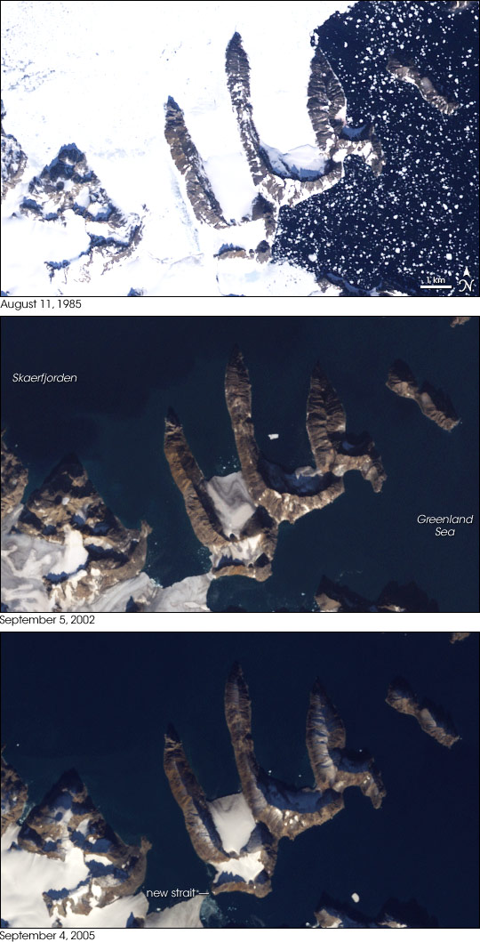
Related to my first post, here is a news story that is a bit dated now, but I find is still relevant. In this case the Greenland ice cap was not only hiding mountains, but the existence of islands that no one knew even existed. Could the largest island in the world actually be just an agglomeration of multiple distinct islands?


Melting Ice Reveals New Island off Greenland

Then again, remember it is still just a matter of perspective. The island revealed in this photo is obviously part of the same mountain range that was thought to be continuous, except in this case, instead of being connected under ice, it is connected under water. The ice is just one layer of the topographic onion. If you remove the water, then the further analysis of topography can continue.

The Earth's surface can roughly be divided into two categories: Ocean Floors and Continent Land Masses. While it would be tempting to distinguish them by the simple presence of water, that would not only be incorrect but also be attributing water to the reason for a difference. The rocks of these two types of land have different chemical compositions, physical attributes and geologic history. It is these concrete differences that results in one being mostly under water and one not, though in fact there are many cases where the ocean floor is exposed above water (Iceland being the most famous example) and where the continental land mass is under water.

Most maps today show the borders of continents to be where the current coast line is, rather than the boundary where continent meets ocean floor. The reason for this is that the oceans have flooded large parts of our continents creating shallow seas. The parts of the continent that are flooded are what we call continental shelves.

This map shows the continents with the continental shelves visible in light blue:


While Greenland is a continental land mass and is most certainly surrounded by water, it does not rise from ocean floor and is not its own continental land mass. As this map shows, it is in fact part of the North American continent.

This makes us beg the question: What is the true definition of an island? In Bali there is a famous Hindu temple that is only accessible by a land bridge at low tide. In Europe there are myriads of castles that are in a similar position. In Maine there are many summer homes that momentarily become islands with the flow of tides. Are these truly islands though? A home owner might like the cachet of saying s/he owns a private island, but it would be a rather dubious claim.

Then again, no one doubts that Greenland is an island. But, in the grand scheme of earth’s geologic time (4.6 billion years and counting), the ebb and flow of tidal waters are not that different from the rising and falling of global sea levels. Instead of rowing over them, there have been many times when it would have been possible to walk up and down the ridges and the valleys of the current continental shelf from Canada to Greenland. The presence of deep canyons eroded by rivers that once flowed to the edge of the continent provide clear proof that this land was once above the sea level.

By peeling away the ocean layer of the onion one can realize how the boundaries we apply to our visualization of the Earth are often just arbitrary and one of many possible options. The melting of glaciers might provide for new surprises in the future (including hermetically sealed liquid lakes kilometers under the Antarctic Ice) but that very melting is causing global ocean levels to rise thereby further shrouding complex topographies under a flat water line.

Thursday, October 6, 2011

Nunataks


Chances are slim that you will find yourself on a stroll in eastern Greenland. After all, it is a bleak cold landscape covered by an ice sheet. In fact, this ice sheet is so thick that you would be strolling at high elevation and be further hampered by thin air.

If you did just happen to be plucked down there though, the only features you could use to orient yourself would be occasional rocky outcrops that protrude above the ice line and provide a relief against the white monotony.

These protrusions, some as small as boulders, are called nunataks and provide just a hint of what is under the ice you would be walking on: whole mountains kilometers high.

The concept of the nunatak is not that different from the "tip the iceberg.” In this case, however, the “tip” is part of a large, interconnected mountain range, and the “ice” is the enveloping medium. Yet, given the difference in scale, it is ironic that more is probably known about icebergs than these mountain ranges.  You can go online these days to get live positioning of icebergsbut if you look at a map of Greenland today all it shows is ice, rather than the actual geologic features of the earth. 


View Larger Map
Don’t you want to know what the features of the largest island on the planet are?


I guess there are practical considerations to displaying the topography as ice though. After all, if you do take that stroll there, you will be walking above the valleys and ridges not trudging up and down them. Furthermore, from a hazard point of view, none of these mountains will sink a Titanic or clip an airplane. Nonetheless, the fact that there are very solid shapes and spaces under the ice provides an alluring mystery, and, as a concept, is a good starting point for this blog.


In this blog I intend to write loosely about 3 topics, and in the process hopefully increase you appreciation of geology:

1.            The aesthetic allure of topographies
2.            The relativistic nature of comprehending and internalizing these topographies.
3.            The processes and timescales involved in the their creation

Of course, it is hard to talk about one of these points without addressing the other. If topography is often not just in the eye of the beholder, but in the mind of the beholder, how can one have a meaningful aesthetic discussion?

In the not-so-subtle example of Greenland, one person might view the topography as ice littered with boulders, another might erase the ephemeral ice from the picture and focus on the erstwhile hidden solid mountainous landscape of the island, whilst a third might erase the mountains from the picture and be interested in seeing the flow, shape and relief of the ice sheet in isolation, as if it were a cast or mold. (In this case, the nanatucks would simply be holes in the ice leading to vast chambers).  

While not so obvious, there are countless examples of “hidden” topography on earth (and surely other planets) that bare similar interest. In exploring them, we can also delve into the interesting geologic processes that created them.